Aug. 3, 2021 Ι Landscape Architecture Magazine
This month, on the riverside terrace of a former pump house in Columbus, Indiana, an exaggerated topographic model of the Mississippi watershed will be installed. It is a hardier object than models meant for conference rooms or museum galleries. In fact, the model’s designer, Derek Hoeferlin, Affiliate ASLA, encourages visitors to pour a glass of water, or beer, over the landscape, to see how much pilsner the Ohio River can take, or how many ounces of stout it requires to overtop the Missouri River. Or, “if it’s coming from the Northwest,” Hoeferlin says, “it might be an IPA.”
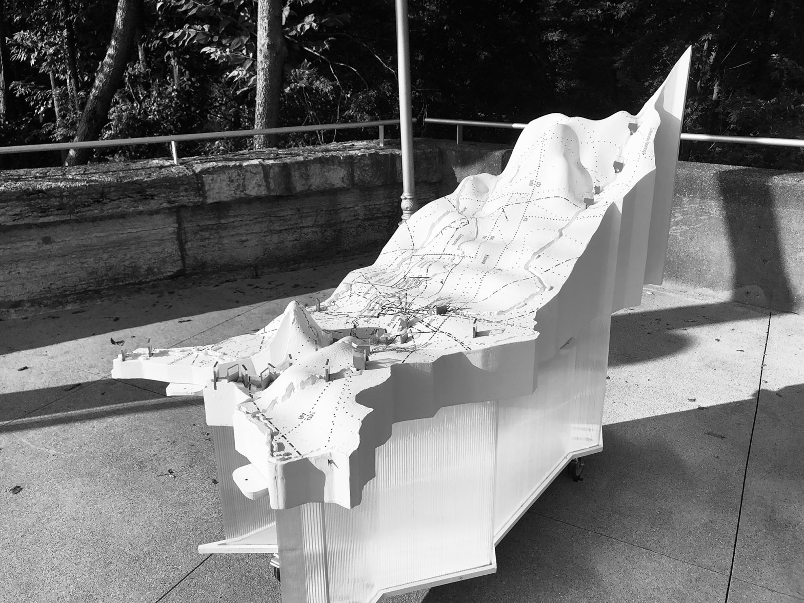
Installed as part of this year’s Exhibit Columbus, a biennial celebration of the Indiana city’s trove of midcentury modern architecture, the model is split into six lobes that fit together like puzzle pieces, representing the Mississippi and its tributary watersheds. It’s an extension of a long-term effort to create an atlas of the Mississippi River Basin, in which Hoeferlin is working to map the basin at a variety of scales and examining the control measures that make the watershed a tool for commerce. The installation, dubbed Tracing Our Mississippi, also includes expository boards, and Hoeferlin plans to host public programming themed on Indigenous rights to the land and water with artists from opposite ends of the Mississippi watershed: Angie Tillges from Minnesota and Monique Verdin from Louisiana.
At about 12 square feet, the installation is a tactile and informal experience that explores regional identity through the continent-spanning scale of watersheds, reinforcing this year’s Exhibit Columbus theme, “New Middles: From Main Street to Megalopolis, What Is the Future of the Middle City?” Hoeferlin, the chair of the landscape architecture and urban design programs at Washington University in St. Louis, is one of nine University Design Research Fellows across seven teams that are part of this year’s program.
Hoeferlin’s model will maintain the stark white, black, and red color scheme of the atlas with the goal of creating a “strange, gallery-white object,” a counterpoint to the leafy outdoor environs at Upland Brewing Company along the Flatrock River. Dams and levees are rendered in red blocks, defiant monoliths in the sculpted topography, and the vertical plane of the model is radically exaggerated. Valleys and hills become hyperbolized into canyons and peaks, more like the Rocky Mountains than river bluffs and alluvial fans. “The only way to really get an understanding of the topography at such a huge scale is to exaggerate the vertical dimension,” Hoeferlin says.
Iker Gil, who curated Exhibit Columbus this year with the critic and LAM contributor Mimi Zeiger, says that this year’s event calls for multiscalar explorations of Columbus and the Midwest, with a special focus on how the region is connected by the Mississippi watershed. Hoeferlin’s project is the most literal encapsulation of this goal. “We thought that this idea of using the Mississippi watershed would be a great way to reveal, explore, [and] understand how some of the things that might be unique to Columbus are also intertwined with other things happening in other places,” Gil says.
Hoeferlin says he hopes this easy-going presentation of common ground shows people that the function and continual management of the Mississippi watershed “is a collective effort. A watershed is a constructed condition. It’s infrastructural, it’s political, and it’s gotten to the point with the Mississippi that it is such a designed and engineered system that it isn’t the classic definition of a watershed. Emphasizing the contrast between ‘natural’ topography and the more rigid river management structures will provide clues to where the river may want to shift its direction. I think there are clues that it can become more dynamic again.”